|
||||||||||||||||||
| Weather and Climate |
||||||||||||||||||
Key Points
|
||||||||||||||||||
Two main climatic zones exist in the Christchurch area. The Port Hills, with a higher humidity and a greater seasonal variability of rainfall, and the plains, which are drier and have more evenly distributed rainfall. The plains are affected by the dry, strong north-westerly winds which dry out the soils, increasing their erosion potential and placing limits on forestry and agricultural productivity. A summary of the City’s main climatic features are as follows:
The weather affects much of the natural and physical environment. Extreme weather events result in stresses on the environment such as droughts, increased groundwater and surface water consumption, natural hazards such as flooding and landslides, and damage to agriculture, horticulture and property. The weather not only influences peoples’ behaviour with regard to resource use, especially water consumption, but it also affects recreational resources and amenity values.
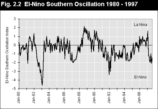
Climatic influences on the environment can occur from either short-term, high-intensity local events or from long-term, large-scale events that are related to global circulation patterns such as the well-publicised El-Nino Southern Oscillation (ENSO). ENSO is controlled by surface water temperature patterns in the southern Pacific Ocean and is measured as an index of air pressure difference between Tahiti and Darwin (Figure 2.2).
Canterbury was in a La-Nina period for much of 1996-97. This produced the following weather conditions in Christchurch:
From March 1997 the ENSO showed the beginning of an El-Nino event. Scientists predict this event could be as large as the El-Nino event of 1982-83. The consequences on the climate of Canterbury during the 1997/98 year are as follows: Winter
Spring
Summer
The end of the El-Nino event produces very dry conditions in Canterbury. Depending on the length of the El-Nino this could occur in the 1997/98 summer or the summer of 1998/99.
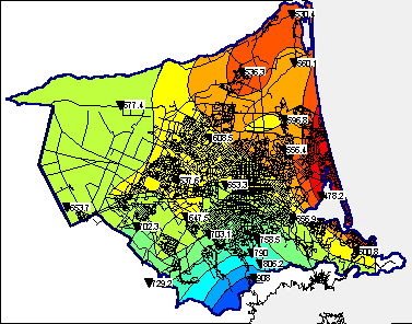
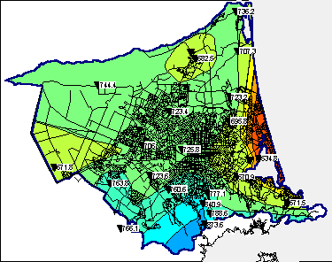
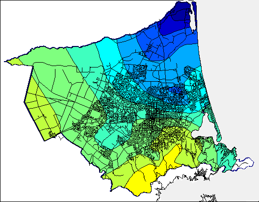
Figure 2.3a shows the mean annual rainfall (3) for the Christchurch City Council’s rain-gauge network. The general pattern of rainfall over the City shows a gradient from high rainfall on the Port Hills, due to orographic influences (4) , to lower rainfall in coastal and north-eastern areas. Much of the urban part of the City receives on average between 600 and 700 millimetres of rainfall a year. The annual rainfall (5) for the year to June 1997 and the percentage difference between the June 1997 annual rainfall and the mean annual rainfall are shown in Figures 2.3b and c respectively. The year to June 1997 is characterised by increased rainfall over much of the City. Only the upper slopes of the Port Hills received the same or less rainfall than the mean annual rainfall for these areas. Areas in the north east of the City received up to 40 percent more rainfall than average. This rainfall pattern is consistent with predominantly La-Nina weather patterns. The rainfall average for all the rain-gauge sites in the City showed the June 1997 year total was 10.5 percent higher at 724 millimetres than the mean annual rainfall of 655 millimetres.
|
||||||||||||||||||