|
||||||||||||||||||||||||||||||||||||||||||||||||||||||||||||||||||||||||||||||||||||||||||||||||||||||||||||||||||||||||||||||||||||||||||||||||||||||||||||||||||||||||||||||||||||||||||||||||||||||||||||||||||||||||||||||||||||||||||||||||||||||||||||||||||||||||
| The Built Environment |
||||||||||||||||||||||||||||||||||||||||||||||||||||||||||||||||||||||||||||||||||||||||||||||||||||||||||||||||||||||||||||||||||||||||||||||||||||||||||||||||||||||||||||||||||||||||||||||||||||||||||||||||||||||||||||||||||||||||||||||||||||||||||||||||||||||||
Key Points
|
||||||||||||||||||||||||||||||||||||||||||||||||||||||||||||||||||||||||||||||||||||||||||||||||||||||||||||||||||||||||||||||||||||||||||||||||||||||||||||||||||||||||||||||||||||||||||||||||||||||||||||||||||||||||||||||||||||||||||||||||||||||||||||||||||||||||
| The changing
size and composition of Christchurch’s population
has major implications for current and future housing
needs. In particular, the number of people expected to be
living in the City over the next 10 to 15 years will
influence the amount and speed at which land is taken up
for residential development. Variations in the
demographic make-up of the population will influence the
type of housing construction and the location of new
developments within the City. These changes are already
apparent when examining the following statistics on
housing in Christchurch.
There were 116,619 occupied dwellings in Christchurch in March 1996. Dwellings grew by 8922 or 8.3 percent between 1991 and 1996, while in the five years to 1991 the increase was 5.9 percent. The City Council estimates that over the next 15 years the number of households will steadily increase to around 140,000 in 2016. In 1996, 75 percent of total dwellings (including private and non-private) in the City were separate houses or units, while 24 percent of dwellings comprised two or more flats or houses joined together within blocks (Table 2.19).
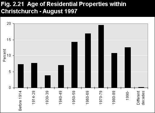
The age structure of Christchurch’s residential properties is shown in Figure 2.21. Three quarters of the residential properties have been built since 1950, with almost 43 percent of properties built since 1970.
The 1970s were characterised by the construction of a large proportion of units. The 10,300 units built during this decade makes up over 50 percent of the units in the present housing stock.
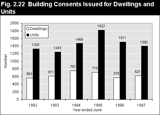
Population counts from the 1996 census identify the amount and location of population growth during the first half of the decade. Building consent records provide insight into how the City’s residential environment is developing to accommodate its growing population and varying lifestyles. The most significant housing trend to emerge in recent years has been the rapid growth in the construction of units or apartments within the City (25) . The overall growth in the number of units in recent years reflects the general trend towards smaller households and the older age structure of the City’s population. This shift also appears to be driven by an increasing demand for a particular lifestyle, often associated with inner city living. Between 1991 and 1997, building consents issued for units accounted for 70 percent of all residential construction within the City. During this period 8757 building consents were issued for units compared with 3831 for separate dwellings. Building consents issued have decreased throughout the last two years since a peak in the year to June 1995 (Figure 2.22). This increase during 1995 appears to be partially attributable to public uncertainty prior to notification of the proposed City Plan (26) for Christchurch. This may have resulted in some developers and home builders obtaining building consents in advance of any possible City Plan rule changes.
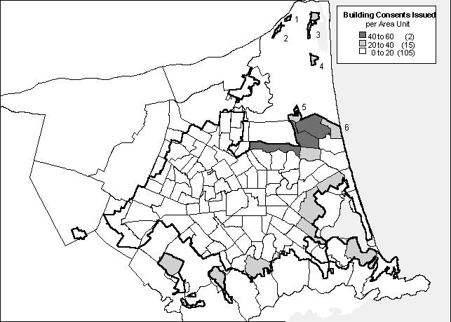
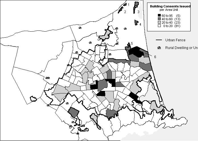
Location of Residential Building Activity There is a clear distinction between the location of new units and new dwellings constructed within the City in the last 12 months. As Figure 2.23 shows, most single dwellings have been constructed in the outer areas of the City, particularly in new subdivisions in the Marshland, Parklands, Travis, Styx, Bexley, Bromley, Ferrymead, Moncks Bay, Cashmere East, Westmorland and Oaklands areas.
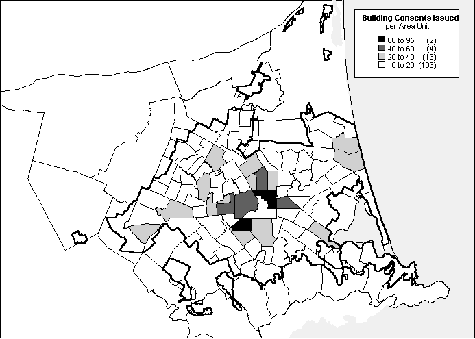
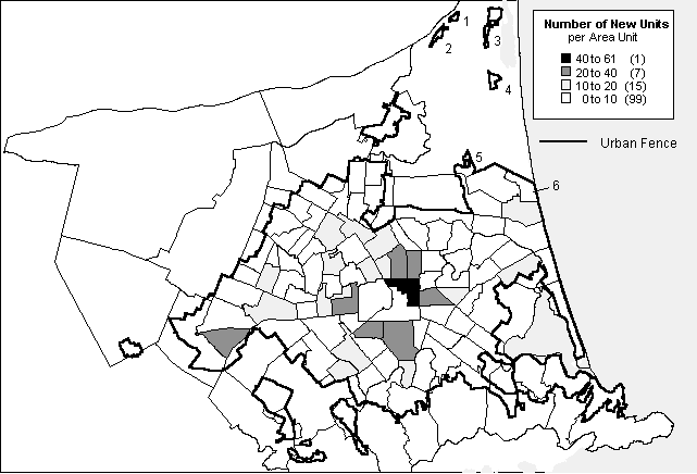
In contrast, the majority of new units or apartments have been constructed in the inner suburbs such as Avon Loop, Addington, Hagley Park, Riccarton, St Albans and Linwood (Figure 2.24). These units have often been built on sections where the existing home is retained or where the structure is removed and replaced by several new units.
Townhouses and apartments are increasingly becoming an integral part of inner-city Christchurch. This development is similar to trends experienced internationally and in other large New Zealand cities. Since 1991, 539 units have been built in the residential zones within the 'four avenues' of Central Christchurch. An additional 124 units have been constructed in the inner city commercial area. In the year to June 1997, a total of 159 units were built throughout the Central City (Table 2.20). This is the largest annual increase of residential units in this area this decade, with over 50 percent more units constructed than during the previous year to June 1996. Most of the redevelopment in the Central City commercial area involves the construction of new buildings rather than the conversion of existing commercial sites.
Construction of Rural Dwellings Overall, the number of houses built in rural zones is very low compared to other parts of the City. Between 1991 and 1997 a total of 176 consents were issued for residential housing in rural zones (27) . This was less than 2 percent of total building activity for the City during this period. Since 1991 the number of residential building consents issued for rural zones has ranged from 19 to 37 per annum (28) (Table 2.21). Over the last two years there appears to be a decrease in the number of building consents issued in rural zones. This could be the result of the new Proposed City Plan which makes it harder to build on rural sections less than four hectares in size. Figure 2.25 shows the location of new rural dwellings constructed during the year to June 1997.
Availability of Vacant Residential Land Christchurch City has a stock of vacant land zoned for residential purposes. The amount and composition of this land is constantly changing as the City expands to accommodate its growing population. In June 1997 the City had 1012.3 hectares of vacant residential land, consisting of 2980 vacant lots (281.7 ha), 536.6 hectares of undeveloped land and 194 hectares of land with potential for development (29) . Table 2.22 shows the majority of the vacant land is on the Port Hills and in the north east of the City. As expected, there is very little vacant land available within the Inner City.
Take-up of Vacant Residential Land Vacant land take-up refers to the amount of land removed from the register through building development, and the creation of roads and reserves. Take-up for the 1996/97 year was 84.7 hectares. This is consistent with rate of take-up for previous years, 87.8 hectares and 81.4 hectares for 1995/96 and 1994/96 respectively. There was a net reduction in the vacant land register of 14 hectares for the 1996/97 year. This is the difference between the take-up of vacant land for development and the addition of vacant land through plan changes, redevelopment, designations being uplifted and other adjustments to the register.
As mentioned previously, units or apartments make up 70 percent of the new residential development within the City. This development is occurring predominantly as infill, with units being built on sections that have been subdivided with the remaining house left or removed. Cross leasing has been the favoured means of subdividing already developed sections for infill housing, although since the notification of the Proposed City Plan cross leasing is decreasing as it now provides no advantage over other forms of subdivision. Figure 2.26 shows the location of resource consents for cross lease subdivision in the City. Greatest concentrations of cross leasing are in the inner ring of Avon Loop, Riccarton, St Albans, Addington, Sydenham and Linwood, and also in South Hornby. This corresponds to areas where much of the unit development has also occurred. The north-east and Port Hills areas have lower numbers of cross lease subdivisions. This could be due to a reasonable stock of vacant land available in these areas.
Growth in population and dwellings puts pressure on the infrastructure of the City. This section describes the City’s infrastructure, and recent changes that meet the needs of new urban development, or which increase the efficiency of services provided to the community. Solid Waste Currently there are three refuse stations in the City - Metro Place in Bromley, Parkhouse Road in Sockburn, and Styx Mill Road in Redwood. Domestic and commercial refuse from these stations is dumped at the City’s only landfill site at Burwood. The Transfer Stations also collect recyclables and compostables. In 1994 the Garden City Compost Plant was opened at Bromley for large scale composting of garden waste. Clean, separated garden waste dropped off at all three Transfer Stations is composted at the Compost Plant into "Envy" garden products. This is then made available for sale at Metro Place Transfer Station, and garden centres throughout the city. Sewage In Christchurch, small plants provide sewage treatment at Belfast and Templeton, but 99 percent of Christchurch sewage is treated at the plant in Bromley. There are 1408 kilometres of sewers and 1165 kilometres of lateral pipes in the City that connect 125,158 customers to the sewage treatment plant. Approximately 70 pumping stations pump the sewage from low areas, particularly near the Avon and Heathcote Rivers. Five terminal pumping stations then pump all the flow to the Bromley treatment plant. The sewage undergoes full primary and secondary processes then passes through oxidation ponds before being discharged into the Avon - Heathcote Estuary. Water The city’s water services include 78 pumping stations and 37 reservoirs. Water is delivered to customers through 3000 kilometres of sub-main pipes and 1300 kilometres of water mains. In the year to June 1997, 5.5 kilometres of sub-main and 8.2 kilometres of water-main pipes were added to the network. The majority of this new piping was the result of subdivision development. Roading The Christchurch roading network consists of 1515.5 km of roads, 25.1km of which are unsealed. Roads within the City are classified in Table 2.23. Ten kilometres of roads were added to the roading network in the year to June 1997. The transport network also includes 2178km of footpaths and 2445km of kerb and channelling with 40km and 63km added to each respectively during the year to June 1997. There are also 139 bridges within the City, of which 21 are for pedestrian use only.
Christchurch residents have a high level of dependence upon the roading network which is reflected in growing vehicle use and ownership within the City. At the 1996 census Currently some 845 percent of households had access to at least one vehicle and 441 percent to two or more vehicles. Power Christchurch City receives electricity (30) from the national grid at four exit points at Bromley, Papanui, Addington and Islington. Electricity is then distributed throughout the City through 1778 kilometres of high and low voltage overhead line and 2996 kilometres of high and low voltage underground cable (31) . During the year to March 1997, there was a decrease of 9 kilometres of overhead line and a increase of 50 kilometres of an underground cable to the Southpower distribution network. Telephone The City has approximately 3000 kilometres of telephone cables. At the end of March 1996 Telecom New Zealand had a total of 161,800 telephone access lines in Christchurch. Of these 118,300 were residential lines and 43,500 were business lines. Telecom estimates the annual growth in access lines in the City is between 2.5 and 3 percent per annum (32) . At the end of June 1997 there were 2219 Telecom and 1410 BellSouth cell phone sites in the City. This was an addition of three Telecom and four BellSouth cellphone sites during the previous year. Resource consents applications are currently being processed for one BellSouth and three Telecom sites.have
|
||||||||||||||||||||||||||||||||||||||||||||||||||||||||||||||||||||||||||||||||||||||||||||||||||||||||||||||||||||||||||||||||||||||||||||||||||||||||||||||||||||||||||||||||||||||||||||||||||||||||||||||||||||||||||||||||||||||||||||||||||||||||||||||||||||||||
|
|
||||||||||||||||||||||||||||||||||||||||||||||||||||||||||||||||||||||||||||||||||||||||||||||||||||||||||||||||||||||||||||||||||||||||||||||||||||||||||||||||||||||||||||||||||||||||||||||||||||||||||||||||||||||||||||||||||||||||||||||||||||||||||||||||||||||||