
This page is not a current Christchurch City Council document. Please read our disclaimer.
![]()
Future
Population Growth[6]
Statistics
New Zealand have recently provided the City Council with revised
population projections for Christchurch (January 1996) which take
into account the higher levels of net migration recorded in
recent years[7]. These projections suggest the
population will continue to grow over the next two decades,
reaching 354,700 people by 2016. However, the rate at which
growth occurs will gradually decline from an annual average
increase of 1.5 percent in 1991-1996 to 0.4 percent in 2011-2016.
This reflects the expected decline in natural increase from 7,490
people to 3,480 people during this period (medium projections)
and the gradual decline of migration from overseas. Statistics
New Zealand predicts the current level of migration is unlikely
to be sustained given historic trends and uncertainty in relation
to central government’s immigration policy. Accordingly they
have projected a decline in net migration from 15,500 people for
the 1991-1996 period to 4,000 people in 2011-2016. Despite this
reduction, the net migration component of population growth is
expected to remain high over the next twenty years.
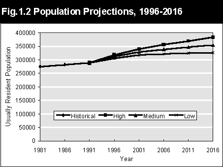
Source: Statistics New
Zealand, 1996 Population Projections (Unofficial)
Where
is Growth Occurring within the City?
Official
information identifying the location of population growth within
the City is not available between each Census. However, building
consent information does provide an indication annually of how
the City is expanding to accommodate it’s growing
population.
During the last five years,
the greatest amount of building activity has occurred in areas on
the residential fringe of the City including Oaklands, Parklands,
Belfast and North Beach (Figure 1.3, (55 kbytes)).
Since 1991, new units or
apartments comprise the majority of this residential growth.
Often these units have been built on sections where the existing
home is retained or where the structure is removed and replaced
by several new units. This process can result in increasing
population densities in the areas concerned.
There is a clear
distinction between the location of new units and new dwellings
within the City. As Figure 1.4 (48 kbytes) shows, most single
dwellings have been constructed in the outer areas of the City,
particularly in new subdivisions at Oaklands, Parklands,
Hawthornden, Marshland, Travis, Templeton, Styx and Belfast. In
most cases these suburbs are areas of lower population density.
In contrast, the majority
of units or apartments have been constructed in the inner suburbs
such as Riccarton, Avon Loop and Merivale (Figure
1.5 (42
kbytes)). Other areas include Sydenham, Sockburn, and
Barrington North. It is likely the population density of these
areas is increasing as this form of construction grows in
popularity.
Over the next twenty years,
the Council, through its City Plan, intends to accommodate
projected population growth by encouraging urban consolidation.
The aim of urban consolidation is to achieve a gradual rise in
average number of households per hectare. This objective will be
achieved by first utilising land within the City for development
(i.e. redevelopment, infill and use of existing greenfield sites)
in preference
to allowing low density
urban sprawl on the rural fringe of the City. As a result
population density is expected to increase in many suburbs as a
result of infill housing and redevelopment of existing sites.
This includes an inner ring of parts of St Albans, Merivale,
Riccarton, Addington, Sydenham, Waltham, Phillipstown, Linwood,
Richmond and Edgeware. Higher densities are also expected around
suburban focal points such as the New Brighton and Papanui
shopping centres.
To also help meet the
expected demand for land in the future the City Plan also has
rezoned around 430 hectares of land on the fringe of the city for
residential use. However this land will not become available for
several years. It is expected that rezoning in the new City Plan
will result in significant population growth in the suburbs of
Burwood and Mairehau in the northeast of Christchurch. Some
smaller areas of new growth are also provided for in the
northwest and on the Port Hills.
The recent emergence of a
higher population growth path is being closely monitored by the
Council. If the present trend persists for another two to three
years, consideration may need to be given to the allocation of
additional land for residential and possibly industrial and
commercial use. The Council will be in a better position to
consider this possibility following the release of detailed
results from the recent Census of Population and Dwellings in
early 1997.