Want to know more about your community?
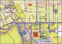 The City Council has produced a set of 20 neighbourhood maps covering all of the city’s urban area. Each booklet unfolds from A4 to A1 size, with a 1:10,000 scale map on one side showing such things as zoning, community facilities, residents’ groups, bus routes, cycle ways and heritage features. This is the first time that this wide range of information has been presented together on the same map. The reverse side contains panels on the area’s history, demographic makeup and important issues and other information relating to that particular neighbourhood. The City Council has produced a set of 20 neighbourhood maps covering all of the city’s urban area. Each booklet unfolds from A4 to A1 size, with a 1:10,000 scale map on one side showing such things as zoning, community facilities, residents’ groups, bus routes, cycle ways and heritage features. This is the first time that this wide range of information has been presented together on the same map. The reverse side contains panels on the area’s history, demographic makeup and important issues and other information relating to that particular neighbourhood.
The neighbourhood maps are designed to help residents, community and business groups identify the unique identity and opportunities of that part of the city. They will be available from early October from your local city area Council Service Centre at a cost of $5 per map |