This page is not a current Christchurch City Council document. Please read our disclaimer.
 |
| May 2003 |
|
Reservations at Canterbury Museum
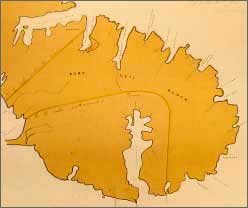
An exhibition about the Ngai Tahu land reserves in Canterbury is on show at Canterbury Museum until the end of June. The Canterbury Native Reserves maps which form the centrepiece of the show are important social, political and technical documents that have not been displayed before and are now in a fragile condition. For the last 150 years they have been kept in the Land Office of Christchurch (now Land Information NZ). The maps and the Native Reserves they represent were created in the 1840s and 50s by Walter Mantell, the Commissioner to Extinguish Native Claims in the Middle Island, and his assistants, surveyors Alfred Wills and Octavius Carrington. The Kemp Purchase in mid-1848 involved a substantial part of the South Island, in the area known today as Canterbury. The deal included land to be reserved for Ngai Tahu of “ample portions for their present and prospective wants”. Between 1 September and 9 December 1848, Mantell and Wills laid out 11 separate reserves between Kaiapoi and Moeraki. The pair travelled this distance on foot and dealt closely with local Ngai Tahu, depending heavily upon them for provisions and local knowledge. Their maps form the core of the exhibition. Also on display in Reservations is the Ngai Tahu Blue Book, a census based largely on information gathered by Mantell during negotiations for the reserves. In order to qualify as Ngai Tahu today, it is necessary to trace a family line to one of the names in this book. Mark Solomon, the Kaiwhakahaere (chairman) of Te Runanga o Ngai Tahu, says the Reservations exhibition is important in terms of the development of the Canterbury region. “It highlights the struggles faced by Ngai Tahu to receive recognition of rights and appropriate compensation for their loss of land within the region,” he says. “I recommend that Cantabrians visit the exhibition to gain a new perspective on some of the forces that shaped Canterbury as we now know it.” |