| |
  April 1999 C H R I S T C H U R C H C I T Y C O U N C I L · Y O U R P E O P L E · Y O U R C I T Y
|
|
 PROPOSED CHANGES
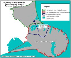
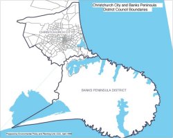
The maps at left and right show the existing Christchurch City and Banks Peninsula District Council boundaries and the proposed new ward boundaries if amalgamation takes place.
Note: Although the Lyttelton-Mt Herbert area would be part of a larger City ward for the purposes of electing councillors, it would stand alone as a Community Board. There would also be a community board for the Banks Peninsula Ward.
|
Give us your views on amalgamation (Submission Period finished)
To assist the City Council in understanding the range of views within the City, you may wish to complete this form.
Please do not complete this form if you are a Banks Peninsula rather than a City resident.
Completed forms must be submitted to the Christchurch City Council by Thursday, 12 May, 1999 to give us time to tell the Local Government Commission your views.
|
| |